Sunday, January 29, 2012

Nærøyfjord


Cette magnifique carte nous vient de Norvège. Le Nærøyfjord est un fjord norvégien. C'est une branche du Sognefjord. Il fait 18 kilomètres de long et de 250 mètres de large par endroits jusqu'à 1 kilomètre.
La rivière Nærøydalselvi coule vers le fjord par la vallée Nærøydalen.
Depuis 2005, le Nærøyfjord a été répertorié au patrimoine mondial de l'UNESCO. Le nom Nærøyfjord provient du dieu norrois 'Njord', le dieu des marins et de la mer.

This beautiful card comes from Norway. The Nærøyfjord is a Norvegian fjord. It is a branch of the large Sognefjord. It is 18 kilometers (11 mi) long and is only 250 metres (800 ft) wide in some parts, and 1 kilometer wide in other parts. The river Nærøydalselvi flows down the valley Nærøydalen.
Since 2005, the Nærøyfjord has been listed as a UNESCO World Heritage Site.
The name Nærøyfjord comes from the Norse god 'Njord', the god of the sailors and of the sea.

Takk Cathrine

Saturday, January 28, 2012

Forêt de Bavière


Voici une carte de la forêt de Bavière en Allemagne et des photos de ses villages. C'est une région de moyenne montagne qui s'étend le long de la frontière tchèque et se poursuit du côté tchèque par la Forêt de Bohême (Šumava).

This is a map of the Bavarian Forest in Germany and pictures of its villages. It is a low-mountain region, which extends along the Czech border and is continued on the Czech side by the Šumava (Bohemian Forest).

Danke schön Julia

Friday, January 27, 2012

Mirów


Cette carte vient de Pologne. Elle nous montre les ruines du château de Mirów.
Mirów est un village dans le sud de la Pologne. Le château du 14ème siècleétait un maillon d'une chaîne défensive de châteaux médiévaux construits le long du Jura polonais.
Mirów est aujourd'hui tombé complètement en ruines.

This card comes from Poland. It shows the ruins of Mirów Castle.
Mirów is a village in southern Poland. The 14th-century Mirów Castle is a part of a defensive chain of medieval castles built along Polish Jura.
Mirow today has sunk completely in ruins.

Dziękuję Pawel


Bo !


Aujourd'hui je vous présente Bo ! Il s'agit d'un chien d'eau portugais, une race de chien. Mais celui-ci n'est pas n'importe quel chien... Il s'agit du chien de la famille Obama. Il est né le 9 octobre 2008 et a été offert aux filles du Président, Sasha et Malia, par le Sénateur Edward M. Kennedy.

Today I present to you Bo! This is a Portuguese Water Dog, a breed of dog. But this is not just any dog... He is the pet dog of the Obama family​. He was born on October 9th, 2008 and was offered to the President's daughters, Sasha and Malia, by Senator Edward M. Kennedy.

Thank you Susan

Thursday, January 26, 2012

USA


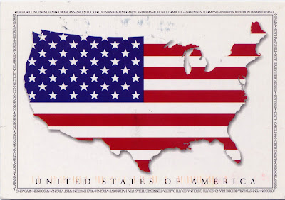
Une carte symbole : la carte des Etats Unis et le drapeaux américain, appelé aussi The Star Spangled Banner. Il se compose de treize bandes horizontales rouges et blanches représentant les 13 premiers états de l'union et un rectangle bleu flanqué de 50 étoiles blanches représentant les 50 états.

This card is a symbol of the United States of America : the map of the country and the national flag. The Star Spangled Banner consists of thirteen stripes of red alternating with white, that represent the 13 first states in the Union, and a blue rectangle bearing fifty white stars representing the 50 states.

Thank you Lynn

La Frise


Cette carte vient de Hollande. La Frise est une province dans le nord des Pays-Bas. Elle compte 646 000 habitants et sa capitale est Leeuwarden. La Frise est essentiellement une province agricole, et c'est la seule province de Hollande où il y a deux langues : le frison et le néerlandais.

This card is coming from The Netherland. Friesland is a province in the north of the Netherlands. The province has 646,000 inhabitants and its capital is Leeuwarden. Friesland is mainly an agricultural province and it is the only province of The Netherland where there are two languages : Frisian and Dutch.

Dank je Viviane

Wednesday, January 25, 2012

L'Ermitage


Cette carte montre le Palais d'Hiver au bord de la Neva à Saint-Pétersbourg, en Russie. Il abrite le très célèbre musée de l'Ermitage. C'est le plus grand musée du monde et l'un des plus anciens. Il a été fondé en 1764 par la Grande Catherine, où elle a vécu jusqu'à 1852. Les collections de ce musée sont composées de plus de 3 millions d'objets dont environ 60 000 sont exposés dans 1 000 pièces. Les bâtiments abritant le musée de l’Ermitage constituent un des principaux ensembles du centre de Saint-Pétersbourg, qui est classé au patrimoine mondial de l’UNESCO.

This card shows the Winter Palace on the banks of the Neva in St. Petersburg, Russia. It houses the famous Hermitage Museum. It is the largest museum in the world and one of the oldest. It was founded in 1764 by Catherine the Great, where she lived until 1852. The collections of this museum consist of more than 3 million items of which approximately 60,000 are exposed in 1000 rooms. The Hermitage Museum is one of the leading ensembles in the center of St. Petersburg, which is a World Heritage by UNESCO.

спасибо Kate


Drapeaux allemands


Voici le drapeaux des autorités fédérales allemandes noir, rouge,or avec au centre l'écu fédéral (Bundesschild). Le drapeau civil allemand ne comporte pas cet écu.
Autour du drapeau fédéral, on voit les 16 emblèmes des 16 Länder d'Allemagne. Il s'agit des seize états qui constituent la république fédérale.

Here are the flag of the federal German authority : black, red, gold with a central escutcheon the Bundesschild. The German civil flag has no such shield.
Around the federal flag, we see the 16 emblems of the 16 Länder of Germany. These are the sixteen states that make up the Federal Republic.

Danke schön Anja

Cathédrale Saint Nicolas


Cette carte postale nous montre la cathédrale Saint-Nicolas de Kiev en Ukraine. Elle a été construite entre 1899 et 1909 par les architectes S. Volovskiy et V. Horodetskiy, sculpteur E.Sala. Elle est de style gothique, et appartient au rite catholique romain.

This postcard shows the St. Nicolas Cathedral in Kiev, Ukraine. It was built between 1899 and 1909 by architects S. Volovskiy and V. Horodetskiy, sculptor E. Sala. It is in Gothic style, and belongs to the Roman Catholic Church.

Спасибі Katya

Tuesday, January 24, 2012

Lukashenko


Alexander Grigoryevich Lukashenko est né en 1954. Il est le Président de la Biélorussie depuis le 20 juillet 1994.

Alexander Grigoryevich Lukashenko was born in 1954. He is the President of Belarus since 20 July 1994.

Дзякуй Аляксандра

Locarno


Cette carte postale nous emmène en Suisse ou plus exactement dans le canton du Tessin à Locarno. La ville compte 15 000 habitants. Elle se situe au bord du lac majeure à la frontière italienne. La langue officielle dans le Tessin est l'italien. Locarno bénéficie d'un climat privilégié et est une destination touristique importante.

This postcard takes us to Switzerland, in the canton of Ticino in Locarno. The city has 15,000 inhabitants. It is located on Lake Maggiore in the Italian border. The official language in Ticino is Italian. Locarno has a privileged climate and is a major tourist destination.

Grazie Andy

Toronto


Une carte de Toronto au Canada. C'est la plus grande ville du Canada et aussi la capitale économique, avec 2,5 millions d'habitants.
A gauche on voit la Tour CN (CN Tower), haute de 553 mètres, contruite en 1976. CN signifie Canadien National, une compagnie ferroviaire. C'est devenu l'emblème de la ville.

A postcard of Toronto in Canada. It is the largest city in Canada and also the economic capital, with 2.5 millions inhabitants.
On the left we see the CN Tower, 553 meters high, built in the 1976. CN means 'Canadian National', a railway company. It became the emblem of the city.

Thank you Corinna

Monday, January 23, 2012

Monastère de Pažaislis


Cette belle carte nous montre l'église et le monastère de Pažaislis situés à Kaunas en Lituanie. Le monastère fut fondé en 1662 pour les ermites de l'ordre des Camaldules. Les bâtiments actuels ont été construits entre 1674 et 1712. En 1832, l'église fut fermée par l'occupant russe et convertie en église russe orthodoxe. Après 1920, l'église en ruine est restituée aux catholiques et est restaurée par les sœurs du couvent de Saint Casimir. Après la Seconde Guerre mondiale, les autorités Soviétiques convertissent l'ensemble des bâtiments en un centre d'archives et hôpital psychiatrique. En 1990, le complexe est restauré et restitué aux religieuses. C'est un des plus beaux exemples de l'architecture baroque dans l'est de l'Europe.

This beautiful card shows the church and the monastery of Pažaislis located in Kaunas, Lithuania. The monastery was founded in 1662 for the hermits of the order of the Camaldolese. The current buildings were built between 1674 and 1712. In 1832, the church was closed by the Russian and converted to Russian Orthodox Church. After 1920, the ruined church is returned to Catholics and is restored by the nuns of the convent of St. Casimir. After the Second World War, the Soviet authorities converted all the buildings in an archive and a psychiatric hospital. In 1990, the complex is restored and returned to the nuns. This is one of the finest examples of Baroque architecture in Eastern Europe.

Ačiū Žymantas


Brooklyn Bridge


Une très belle vue de New-York et du fameux pont de Brooklyn. Ce pont au dessus de l'East River est long de deux kilomètre. Il a été ouvert en 1883 après 14 ans de travaux. Il relie Manhattan à Brooklyn.

A very beautiful view of New York and famous Brooklyn Bridge. This bridge over the East River is two kilometers long. It was opened in 1883 after 14 years of work. It connects Manhattan to Brooklyn.

Thank you Susan

Finlande et Laponie


Des cartes de Finlande. La première nous montre tout le pays et de belles images typiques du pays. La seconde est une carte de la Laponie, territoire du grand Nord s'étalant du cercle polaire Arctique (66°33' 07") au Cap Nord (71° 10' 21''). La Laponie s'étend sur quatre pays : la Finlande, la Norvège, la Russie et la Suède.

Two maps of Finland. The first shows the country and beautiful typical pictures of the country. The second is a map of Lapland, an area spanning the far north of Arctic Circle (66° 33' 07") to the North Cape(71° 10' 21"). Lapland covers four countries : Finland, Norway, Russia and Sweden. 

Kiitos Solli and Marja


Sunday, January 22, 2012

Singapour


Singapour est une ville état située en Asie du Sud-Est. Elle est composée de 64 îles et mesure 647 km². Elle se trouve à l'extrême sud de la péninsule Malaise. L'économie de Singapour est prospère, c'est une plaque tournante du commerce entre la zone Pacifique et l'Europe. Singapour se classe 4è mondial au niveau du pouvoir d'achat de ses habitants après le Qatar, le Luxembourg et la Norvège. Très densément urbanisée, la ville bénéficie tout de même, grâce au climat équatorial, d'une végétation luxuriante en plein centre-ville qui lui vaut le surnom de ville jardin.

Singapore is a city-state in Southeast Asia. It consists of 64 islands and 647 km². It is located in the extreme south of the Malay Peninsula. Singapore's economy is thriving, it is a hub of trade between the Pacific and Europe. Singapore is ranked 4th in the World for the purchasing power of its inhabitants after the Qatar, Luxembourg and Norway. Densely urbanized, the city has, thanks to the equatorial climate, a lush vegetation in the city center which earned him the nickname of Garden City.

Terima kasih Flamingold

Alhambra de Granada


Cette magnifique carte postale montre l'Alhambra de Grenade, en Andalousie, Espagne. Le mot Alhambra est une déformation de mots arabes signifiant "la forteresse rouge". C'est un palais et une forteresse construits au milieu du 14e siècle par les souverains maures de l'émirat de Grenade. Le Palais mauresques de l'Alhambra a été construit pour les derniers émirs musulmans d'Espagne et leur cour. Après la reconquête (Reconquista) par les monarques catholiques (los Reyes Católicos) en 1492, certaines parties ont été utilisés par les dirigeants chrétiens puis pour construire le palais de Charles V en 1525. C'est maintenant l'une des attractions touristiques majeures d'Espagne. L'Alhambra est inscrit au patrimoine mondial de l'UNESCO.

This beautiful postcard shows The Alhambra in Granada, Andalusia, Spain. The word Alhambra is a deformation of Arabic words and means "the red fortress". It is a palace and fortress complex constructed during the mid 14th century by the Moorish rulers of the Emirate of Granada. The Alhambra's Moorish palaces were built for the last Muslim Emirs in Spain and its court. After the reconquest (Reconquista) by catholic monarchs (los Reyes Católicos) in 1492, some portions were used by the Christian rulers and for the construction of Charle V's Palace in 1525. It is now one of Spain's major tourist attractions. The Alhambra is a UNESCO World Heritage Site.


Gracias Aurora


Fagus Werk


L'usine Fagus (Fagus Werk en Allemand) est une usine de chaussures située à Alfeld en Allemagne. Construite entre 1911 et 1913, c'est un exemple important d'architecture moderne du début du XXè siècle. L'usine a été dessinée par les architectes Walter Gropius et Adolf Meyer. C'est la première fois qu'on construit une façade tout en verre qui ne sépare plus de façon formelle l'intérieure et l'extérieure. L'usine a été inscrite au Patrimoine mondial se l'UNESCO en 2011.

The Fagus factory (Fagus Werk in German) is a shoe factory located in Alfeld, Germany. Built between 1911 and 1913, it is an important example of modern architecture of the early twentieth century. It was designed by the architects Walter Gropius and Adolf Meyer. This is the first time we built an all-glass facade that not separates formaly indoor and outdoor. The factory was included in UNESCO World Heritage in 2011.

Danke schön Anja

Saturday, January 21, 2012

Tallinn


Tallinn est la capitale de l'Estonie. Cette ville située au bord de la mer Baltique compte environ 410.000 habitants. Jusqu'en 1918 la ville s'appelait Reval. Dès les IXè et Xè siècle, la ville était une place commerciale très connue dans l'Europe du Nord.
Cette carte postale représente la place de l'hôtel de ville, où se trouve la plus ancienne pharmacie d'Europe (Raeapteek) encore en activité, elle date du XVe siècle. L'Hôtel-de-Ville de style gothique, doté d'un clocher, date du XIVe siècle.
Le centre historique de Tallinn est inscrit au patrimoine mondial de l'UNESCO.

Tallinn is the capital of Estonia. This town on the shores of the Baltic Sea has about 410,000 inhabitants. Until 1918 the city was called Reval. During the ninth and tenth centuries, the city was already a commercial place well known in Northern Europe.
This postcard shows the town hall square, where the oldest pharmacy in Europe (Raeapteek) is still in operation, it dates from the fifteenth century. The Town Hall is in the Gothic style, with a bell tower, and dates of the fourteenth century.
The Old Town of Tallinn is a UNESCO World Heritage Site.

Tänan Jüna


Petronas twin towers


Ces deux cartes nous montrent des points de vues différents sur les tours Petronas à Kuala Lumpur en Malaisie. Ces tours jumelles ont été conçues par l’architecte argentin Cesar Pelli. Elles ont nécessité six ans de travaux et furent inaugurées en 1998. Hautes de 452 mètres et 88 étages, ces tours ont été les plus hauts immeubles du monde de 1998 à 2004, date à laquelle elles furent détrônées par Taipei 101. Une passerelle d’acier relie les deux tours à 170 mètres du sol au niveau des 41e et 42e étages, elle est essentiellement destinée à permettre une meilleure évacuation en cas d'incendie. Les tours comprennent 78 ascenseurs !

These two postcards show different views of the Petronas Towers in Kuala Lumpur, Malaysia. These twin towers were designed by Argentinean architect Cesar Pelli. They needed six years of work and were inaugurated in 1998. High of 452 meters and 88 floors, the twin towers were the tallest buildings in the world from 1998 to 2004, when they were dethroned by Taipei 101. A steel bridge (skybridge) connects the two towers 170 meters above the ground at the 41st and 42nd floors, it is primarily intended to allow better evacuation in case of fire. The towers include 78 lifts!

Terima Kasih Ashley and Nisnoopy


République de Chine


Cette carte peinte représente le drapeau de la République de Chine ou Taïwan. La séparation de Taïwan et de la Chine Populaire date de 1949, mais n'est pas reconnue par tous les états, ainsi la République populaire de Chine (Pékin) ne reconnait pas la République de Chine (Taïwan).
La République de Chine et la République populaire de Chine revendiquent chacune la pleine souveraineté sur la totalité du territoire chinois.
Le drapeau fut adopté en 1928 à la suite de la victoire des forces du Kuomintang dans l'expédition du nord. Il représente en haut a gauche, le « ciel bleu au soleil blanc », symbole du Kuomintang, et un fond rouge, symbole du sang versé pour la révolution chinoise.

This painted card represents the flag of the Republic of China or Taiwan. Taiwan and mainland China separated in 1949, but Républic of China (Taiwan)is not recognized by all states and the People's Republic of China (Beijing) does not recognize the Republic of China (Taiwan).
The Republic of China and China each claim full sovereignty over all of China.
The flag was adopted in 1928 following the victory of the Kuomintang forces in the Northern Expedition. It represents at top left, the "white sun in blue sky", the symbol of the Kuomintang, and a red background, symbolizing the blood shed for the Chinese revolution.

謝謝 Apple

Friday, January 20, 2012

Hollande


Une carte de la Hollande montrant toutes les villes et principaux monuments.
Le timbre est issue de la collection postcrossing !

A map of Holland showing all cities and main monuments.
And the stamp is from the collection Postcrossing !


Dank je Kitty

Tuesday, January 17, 2012

Vilnius


Vilnius est la capitale de la Lituanie. C'est une petite ville d'environ 500 000 habitants. Le centre historique de Vilnius est particulièrement bien conservé. Il est entièrement classé au patrimoine mondial de l'UNESCO. Sur cette vue générale de la ville, on voit la Cathédrale et l'église Sainte Anne.

Vilnius is the capital of Lithuania. It is a small city of about 500,000 inhabitants. The historical center of Vilnius is particularly well preserved. It is fully classified World Heritage by UNESCO. On this general view of the city, we see the Cathedral and the Church of St. Anne.

Kiitos Suvi